Showing posts with label GIS Programming. Show all posts

Friday, August 9, 2013

Module 11: Sharing Tools

Random Buffer Tool and Result

This is a screenshot of custom tool that can be easily shared between users. The tool incorporates a Python script that was imported into the tool. The tool prompts the user to select their own parameters in the dialog through help tips. Even if the user has no knowledge of Python scripting, a well designed geoprocessing tool can increase the users productivity.

Friday, August 2, 2013

Module 10: Creating Custom Tools

Part 2 Screenshot: Multi Clip Custom Script Tool 

This custom script tool was created in using the Add Script Wizard in ArcMap. A script tool allows a user with no knowledge of Python to perform geoprocessing tasks by simply entering tool parameters using built in validation and error-checking. 

Part 3 Screenshot: Multi Clip Messages

This is a screenshot of the results window after the custom script tool completed its tasks. Script tools enable Python to write messages to the results window during a geoprocessing task informing the user of the tools progress. 

Friday, July 26, 2013

Participation 2

Locating Opportunities for Outdoor Action and Adventure Recreation and Tourism in the Western Cape: A GIS Application


In his journal article, Johannes H. Van Der Merwe demonstrates how GIS is used to create a model for entrepreneurial and regulatory planning. The subject area for the article is the Western Cape Province of South Africa, “a premier tourism destination”. Recreation, marketing and tourist preference data was collected and given spatial attributes. The data was then analyzed by creating a weighted overlay map of the area. Planners and entrepreneurs are now able to use the results of the analysis to help them make better decisions for developing future recreation and ecotourisim attractions.

Reference:

VAN DER MERWE, J. H. (2012). LOCATING OPPORTUNITIES FOR OUTDOOR ACTION AND ADVENTURE RECREATION AND TOURISM IN THE WESTERN CAPE: A GIS APPLICATION. South African Journal For Research in Sport, Physical Education & Recreation (SAJR SPER). 34(2). 197-214. doi: 20121127. Retrieved from http://ehis.ebscohost.com.ezproxy.lib.uwf.edu/ehost/detail?sid=3ca29466-6ea6-452e-a3c7-b07ec8567cfa%40sessionmgr4&vid=8&hid=6&bdata=JnNpdGU9ZWhvc3QtbGl2ZQ%3d%3d#db=s3h&AN=83582233

Module 9: Debugging and Errors

Part 1 Result

This is a screenshot of the PythonWin Interactive Window after running the first script I successfully debugged using the methods we learned in this weeks lab. The script displays the names of the airports in the airport shapefile for the State of Alaska. 

 Part 2 Result

This is a screenshot of the PythonWin Interactive Window after running the second script I successfully debugged using the methods we learned in this weeks lab. The script displays the name of each data frame along with the name of each layer in an ArcMap document.

Friday, July 19, 2013

Module 7: Geometry and Rasters

Text File Result

This is a screenshot of a text file created by a Python script. The script writes the Object ID of the feature, the vertex number, the XY coordinates of the vertex, and the feature name for each vertex in a shapefile using the Search Cursor function in Python.

Final Raster Result

 
This is a screenshot of the ArcMap desktop window showing the result of a Python script. The script creates a temporary land cover raster where the forest land cover was reclassified, and four temporary elevation rasters for minimum and maximum slopes and aspects. The five temporary rasters are then combined into the Final Raster seen here.

Friday, July 5, 2013

Module 6: Working with Spatial Data

Script Result


This is the result of a script that creates a new file geodatabase and populates it with feature classes. A friendly message keeps you apprised of the script's status as it runs. Then it determines which cities in New Mexico are designated as a county seat and populates a dictionary with the city's name and population. And finally, the dictionary is printed for your viewing pleasure.

Sunday, June 30, 2013

Module 5: Geoprocessing with Python

Script Result

This is a screen shot of the Pythonwin Interactive Window displaying the successful result of a script written to run three geoprocessing tools. The first tool adds xy coordinates to the features of a point shapefile called hospitals. The second tool creates a 1000 meter buffer of the hospitals shapefile. And the third tool dissolves the hospital buffers into a single polygon feature. Writing and running a script does not automatically display each tools messages in the interactive window. To get feedback on the result of a tool, it is necessary to instruct Python to print each tools messages. I successfully incorporated two while loops to accomplish this part of the lab.

Saturday, June 15, 2013

Python Fundamentals II

Python Dice Game Result 

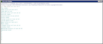
The result of this script lists eight players with their score from the roll of a dice and whether or not they are a winner. The list of numbers at the bottom are the result of a while loop counting from zero to five.

Wednesday, June 5, 2013

Python Fundamentals I

Successful Result

This is a screen shot of a script result that displays my last name. Then it calculates the length of my last name and displays the result multiplied by 3.

Tuesday, May 28, 2013

Geoprocessing in Arc

Soil Erase Script Output


This simple image is the result of a model created in ModelBuilder. The model was designed to exclude soil, previously identified as not prime farmland, from a given basin.

Tuesday, May 21, 2013

Intro to Python


This is a screen shot of the file folder paths created by running a Python script. This script accomplished in seconds what had been a tedious and time consuming task in the past. I'm kind of excited to learn what else I can do with Python.